


Dual Function Vocal Drone Shouting Lighting Effective Lighting Distance 100m

Contact Person : Tina Yu
Phone Number : 86-10-57621296
WhatsApp : +8613683015302


| Minimum Order Quantity : | 1 set | Price : | USD50000-USD70000 |
|---|---|---|---|
| Packaging Details : | Export package | Delivery Time : | 30 working days |
| Payment Terms : | T/T | Supply Ability : | 20 Sets/Month |
| Place of Origin: | China | Brand Name: | TOPSKY |
|---|
|
Detail Information |
|||
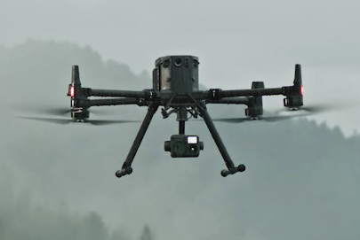
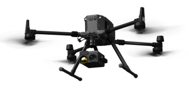
| Unfolding Size: | L810 MmxW670 MmxH430 Mm | Symmetric Motor Wheelbase:: | 895 Mm |
|---|---|---|---|
| Weight (excluding Battery):: | About 3.77 Kg | Maximum Take -off Weight:: | 9.2 Kg |
| Max Flight Speed:: | 23 Meters/s | Max. Flight Time:: | 55 Minutes |
| High Light: | 1080p detection drone,disaster response detection drone |
||
Product Description
| 1. Product overview |
| The drone can quickly obtain the global perspective of the disaster accident scene. Some scenes can replace artificially close to reconnaissance. Through the hot imaging camera and the smoke to identify the fire points and high temperature areas, in the rescue of the hazardous chemical tanks, large -scale mountain fires The efficiency of rescue and fire extinguishing is greatly improved in the scenes such as combustion, which has an important promotion role in the development of fire rescue work. |
| 2. Scope of application |
| Applicated in the field of emergency rescue |
| 3. Product features |
|
1. New map biography, stable play The UAV uses the O3 Map Industry Edition, supporting the 1080P high -definition transmission of the Three Road, with a transmission distance of 20 kilometers. Both the aircraft and the remote control are equipped with a four -antenna receiving system. The two antenna emittering signals with the best signal can be intelligently selected. The four antennas are received at the same time. The anti -interference capacity is significantly improved and the transmission is more stable. 4.4G enhanced map transmission Not only that, the O3 diagram signal can also cooperate with the 4G network. When the O3 diagram signal is disturbed, the drone can still ensure the stability of the diagram through the 4G network and calmly cope with the signal cover in complex environments such as urban buildings. 2. New detection function in place, avoid the risk of forgetting to twist the sleeve, and make the flight more at ease. 3. The fuselage flying camera has excellent night vision ability, which can clearly present the night environment and obstacles. Cooperate with the positioning function to further guide safe flights, and work at night is more confident. 4. The drone is equipped with a six -way visual system and infrared perception system, which brings six -way environmental perception, positioning and obstacles, and provides comprehensive protection for flight. 5. Install the millimeter wave radar, the drone can detect the small obstacles within the range of 360 ° and above, and avoid obstacles in time. The effective detection distance can reach up to 30 meters, which further improves the safety factor. 6. UAV aircraft systems and sensor systems use redundant design, which can ensure flight safety to the greatest extent, so that you can rest assured to deal with the harsh operating environment. 7. Support various route tasks such as aerial flight, air -building aerial photography, tilt photography, and band flights. With the help of imitation land flight or intelligent swinging function, efficient collection data, cooperating with DJI Smarttop software, quickly obtain high -definition two -dimensional and Three -dimensional digital results achieve high -precision, high -efficiency surveying and mapping operations. 8. With high -precision score positioning and real -time maps of the cloud, drones can connect the sky, ground end, and clouds. After the aircraft completes the image collection, the drone can quickly model the work site and pass the command information to the aircraft and ground operators. Both the remote control and the drone support points, lines, face drawing and real -time uploading, and live broadcast of the aircraft real -time operation screen, break through the barriers of communication, and achieve empty ground collaborative operations. 9. Recording through online tasks can generate inspection routes. After being stored as a route file, it can be called at any time to achieve automated operations, so that repeated inspections are no longer time -consuming and laborious. When using the accurate re -shooting function, support automatic frame selection and manual adjustment shooting goals, improve the accuracy of repeated shooting, and improve the quality of inspection operations. |
| 4.Main specification |
|
UAV parameter: 1. Size (unfolding status, no paddle leaves): 810 mm long, 670 mm wide, 430 mm high 2. Size (folding status, paddle leaves): 430 mm long, 420 mm wide, 430 mm high 3.Symmetric motor wheelbase: 895 mm 4.Weight (including the lower single gimbal bracket): weight (excluding battery): about 3.77 kg weight (including dual battery): about 6.47 kg 5. Maximum load of Single Shooting Ball: 960 grams 6.Maximum take -off weight: 9.2 kg 7.Working frequency: 2.4000 GHz to 2.4835 GHz 5.150 GHz to 5.250 GHz(CE:5.170 GHz to 5.250 GHz) 5.725 GHz to 5.850 GHz Some areas do not support 5.1 GHz and 5.8 GHz bands, and the 5.1 GHz bands in some areas are only supported indoors. For details, please refer to local laws and regulations. 8. Launch power (EIRP): 2.4000 GHz to 2.4835 GHz: <33 DBM (FCC), <20 DBM (CE/SRRC/MIC) 5.150 GHz to 5.250 GHz (CE: 5.170 GHz to 5.250 GHz): <23 dBM (CE) 5.725 GHz to 5.850 GHz: <33 DBM (FCC/SRRC), <14 dbm (CE) 10. Hanging accuracy (windless or breeze environment): 11. Vertical: ± 0.1 meters (when the visual positioning is normal) ± 0.5 meters (when GNSS works normally) ± 0.1 meters (when RTK positioning is normal) 12. Level: ± 0.3 meters (when the visual positioning is normal) ± 1.5 meters (when GNSS works normally) ± 0.1 meters (when RTK positioning is normal) RTK position accuracy (at RTK Fix): 1 cm +1 PPM (level) 1.5 cm +1 PPM (vertical) 14. Maximum rotation angle speed: Pental axis: 300 °/second Axis: 100 °/second Maximum pitch angle: 30 ° 15. When using N mode and enable the front vision system, it is 25 °. 16. Maximum rising speed: 6 meters/second 17. Maximum reduction (vertical): 5 meters/s 18. Maximum tilt falling speed: 7 meters/second 19. Maximum flight speed: 23 meters/s 20. Maximum flight altitude: 5000 meters, use 2110S paddles, take the take -off weight ≤7.4 kg. 7000 meters, use the 2112 plateau's mute paddle leaves, the take -off weight ≤ 7.2 kg. 21. Maximum wind speed: 12 meters/second 22. The longest flight time: 55 minutes 23. In the state -free environment and empty load, fly forward at a speed of about 8 meters/sfen to the remaining 0% of the power. For reference only, the actual use time may be due to different flight methods, accessories and environmental environment. For differences, please pay attention to the APP prompt. 24. Adaptation to DJI Global: 25. Zen Si H20, Zen Si H20T, Zen Si H20N, Zen Si P1, Chan Si L1 26.IP protection level: IP55 27.The protection level is not permanent standard, and the protection ability may decline due to product wear. 28.GNSS: GPS + Glonass + Beidou + Galileo 29.Working environment temperature: -20 ° C to 50 ° C Double light module parameters: 1. Video compression: H.264 2. White balance: Automatic 3. gain control: Automatic 4. Non -Light: Support 5. Remote upgrade function: support 6. Device log function: support 7. Wide dynamic: 120db 8. Signal to noise ratio: greater than 52db 9.AI noise reduction: support 10.AI HDR: Support 11. Exposure mode: Automatic 12. Zooming lens Focus: F = 7.1 ~ 171mm, 30 times optical zoom, 160 times comprehensive zoom 13. Number of aperture: F1.6-F5.1 14.Vision angle (D × H × V): 58.4 ° Wide; 2.1 ° Tele 15. Vertical: 34.1 ° Wide; 1.2 ° Tele 16. Dialogue: 65.5 ° wide; 2.4 ° Tele 17. Day and Night Mode: Electric IR-CUT infrared filter ⽚ 18. Laser ranging distance: 5-1000M 19. Laser ranging wavelength: 905nm 20. Laser ranging measurement accuracy: ± 1m 21. Infrared thermal imaging ① sensor: non -refrigerated oxidation (VOX) (VOX) ② Loster: DFOV: 45.76 ° ③ Focus: 19mm ④ aperture: f/1.0 ⑤ Number change: 8 times ⑥ Video resolution: 640 × 512 ⑦ Like the size of the yuan: 12 μm -Temperature measurement range: -20 ℃ ~+150 ℃/0 ℃ ~+550 ℃ 22. Yundai angle shake volume: ± 0.008 ° 23. Control rotation range: pitch: -120 ° ~ + 30 °, partial flight: ± 320 ° 24. Interface: DGC2.0 25. Power: 13.6V/2A 26.SD card interface: d hold Microsd card storage (most ⼤ 128G) 27. Power consumption: 8W 28. Protection level: IP55 29. Work temperature and humidity: -20 ° C ~+60 ° C, humidity ⼩ 95% 30. Size: L 179mm * W126.5mm * H190mm 31. Weight: 1020g ± 5 32. Two -purpose day and night, full color imaging under extremely low illumination 33. There is no obvious drag in the sports objects in the night scene 34. Night 1080P ultra -clear picture quality 35.20 times optical zoom 36. Support dynamic strong light suppression, fog removal function, 3D digital noise reduction, high -precision three -axis High -definition night visual module parameters: 1. Divine use of day and night. Under extremely low illuminance, the sports objects in the night scene can be used in full -color. 2. 20x optical zoom 3. Support dynamic strong light suppression, fog removal function, 3D digital noise reduction, high -precision three -axis 4. 2 million pixels, full color 1920*1080p 5. Powering: -120 ° ~ + 30 °, partiality: ± 320 ° 6. Microsd card storage (most ⼤ 128g) 7. Protection level: IP44 8. Size: L 175mm × W 126.5mm × H 152mm 9. About 790g Gas detection module parameters: 1. Size and weight: size ≤158*103*87.5 (mm), weight ≤490g; 2. Detection items: A gas detector can install the number of sensors at the same time ≥9 (excluding temperature and humidity sensors), and the detection items include, but not limited to PM2.5, PM10, CO, NO2, O3, SO2, VOCs and other gases And can display temperature and humidity synchronously; 3. Power supply method: at least 3 different power supply methods 4. With a high -bright concentration warning light prompt: color and alarm value can be customized, and can be set to automatically follow the gas concentration change 5. With an independent mobile communication module, no transmission distance restrictions, the data concentration data of pollutants or the record rate is not less than 1Hz, and supports data breakpoints 6. Support the real -time monitoring value and equipment working status in the planned and flight control software in the official route of drone 7. Support the gas sampling function, you can trigger gas collection through the official flying control software and gas monitoring software of the drone at the same time, adapting to different capacity gas pockets (0.5L-4L), monitor the air pressure in the bag in real time. Stop, no manual intervention; 8. Support ultrasonic wind speed wind direction detection function, no motion components, with drone flat movement compensation algorithm, drone posture compensation algorithm, drone rotation motion compensation algorithm, which can realize the actual wind speed wind direction information information on the side movement and side motion. 9. Support nuclear radiation detection function, the detected energy range is 30KEV ~ 3MEV, the detected dose rate range is 0.05USV/H ~ 10MSV/H Lidar module parameters: 1. Size: 152 × 110 × 169mm 2. Weight: about 930 ± 10g 3. System power consumption: 30W 4. Protection level: IP54 5. Support model: Jingwei M300 RTK 6. Work temperature: -20 ℃ to 50 ℃ 7 Storage temperature; -20 ℃ to 60 ℃ 8. Variety; 450m @ 80%, 0 klx; 190m @ 10%, 100 klx 9. Point cloud data rate: single back wave: 240000PTS/s; Multiple waves: 480000PTS/s 10. System accuracy; graphic accuracy: 10cm @ 50m; High -speed accuracy: 5cm @ 50M 11. Real -time cloud color coloring mode; real color; according to the reflectance of color; color as high; 12. distance accuracy: 3CM @ 100M 13. Max. support the number of echo: 3 Scan mode: Repeated linear scanning mode; non -repeatable petal scanning mode 14.fov: Repeated linear scanning mode: 70.4 ° × 4.5 °; Non -duplicate petal scanning mode: 70.4 ° × 77.2 ° 15.imu update frequency: 200Hz 16. Resolution: 1280 × 960 17. Sensor size: 1 inch 18. Effective pixels; 20 million 19. Image size; 4864 × 3648 (4: 3); 5472 × 3648 (3: 2) 20. Focus; 8.8mm / 24mm (equivalent) 21. angle shake amount; 0.01 ° 22. Controlled rotation range: pitch: -120 ° to+30 °; Transfer: ± 320 ° 23. Work mode; follow/freedom/return medium 24. Original data storage; photo/IMU/point cloud data storage 25. Point cloud data storage; real -time modeling data storage 26. Supporting the type of memory card; Microsd card: Microsd card with a transmission speed reaches the UHS-1 rating or CLASS10 and above, with a maximum support of 256GB capacity |
![]()
Enter Your Message
Mission:To let the world more safer.
Technical route:To solve the problem of traditional security
with non-traditional technology.
Customer groups:Public security and production safety
| Beijing Topsky Century Holding Co.,Ltd |
| 10B NO.17 HuanKe Middle Road Jin Qiao Industry Base Tongzhou District Beijing China 101102 |
| 86-10-5762-1296 |
| sale2.ex@topskytech.com |